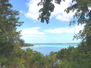
Environmental Disturbance in the Greater Yucatan
The Environmental Disturbances in the Greater Yucatán (EDGY) project is a joint effort of Rutgers University, Clark University, The University of Virginia, and El Colegio de la Frontera Sur (ECOSUR). Our project seeks to understand the socio-ecological relationship between both human and of natural disturbances, with a focus on the 2007 landfall of Hurricane Dean, and forest cover in the Yucatán Peninsula. We employ a combination of methods including, but not limited to, remote sensing analysis, ecological field assessments, household- and community-level interviews and surveys.
Current research efforts include understanding how land use and biophysical properties combine to inform tropical forest resilience and regeneration following disturbances. This objective includes multi-scalar investigation of 1) regional mapping and monitoring of tropical secondary forest using remote sensing and spatial modeling 2) individual- and plot-level biomass recovery analysis 3) feedback between land use and forest ecosystem dynamics through participatory mapping and community focus groups.
Selected related publications from the Land Systems Science Research Group:
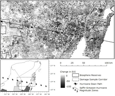
Landscape analysis of forest damage after Hurricane Dean 2007: Rogan, Schneider et al., 2011
Effects of wind disturbance on biodiversity: Vandecar, Lawrence, Richards, Schneider et al., 2011
See more publications from the Southern Yucatan Peninsula Region
Current research efforts include understanding how land use and biophysical properties combine to inform tropical forest resilience and regeneration following disturbances. This objective includes multi-scalar investigation of 1) regional mapping and monitoring of tropical secondary forest using remote sensing and spatial modeling 2) individual- and plot-level biomass recovery analysis 3) feedback between land use and forest ecosystem dynamics through participatory mapping and community focus groups.
Selected related publications from the Land Systems Science Research Group:
Landscape analysis of forest damage after Hurricane Dean 2007: Rogan, Schneider et al., 2011
Effects of wind disturbance on biodiversity: Vandecar, Lawrence, Richards, Schneider et al., 2011
See more publications from the Southern Yucatan Peninsula Region
Project Support
|
|
|

|

|

|
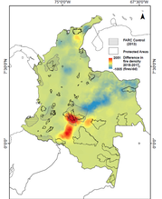
Mapping Landscape Configuration in the Orinoquía, Colombia: The potential for land change in a post-conflict era.
Influenced by Dr. Laura Schneider's work as a Fulbright Distinguished Chair at Universidad Nacional, Bogotá Colombia, this project examines how alternating periods of war and peace directly effect landscapes, through shifts in natural resource availability, the opening of new frontiers, and access to diverse markets. Historically, the Orinoquía region in Colombia has been the center of Colombian conflict between the state and guerrilla groups, subsequently promoting biological conservation of biodiverse tropical forest through limited access to land and agricultural development. With the rise of a new peace treaty in Colombia, and conflicting promises for frontier development and resource use, the tropical forests and potential frontier of the Orinoquía region provide the unique opportunity to analyze periods of war and peace as drivers of land cover change.
Selected Related Publications from the Land Change Science Research Group:
Unforseen deforestation in a post-conflict era Armenteras et al., 2019
Selected Related Publications from the Land Change Science Research Group:
Unforseen deforestation in a post-conflict era Armenteras et al., 2019
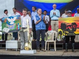 Photo Credit: The New York Times Photo Credit: The New York Times
Project Support
|
Armenteras et al., 2019
|
|

|

|
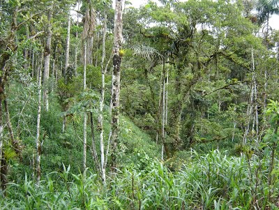
The Spontaneous Spread of Silvopastoral Landscapes in the Ecuadorian Amazon
With the continuing decline in the global extent of tropical forests, agriculture dominated landscapes now cover ~50% of the tropical biome. In this context our ability to understand and influence tropical biodiversity depends in large part on our understanding of actively managed landscapes. Given that pastures cover most agricultural lands in the Neotropics, significant changes in their biodiversity, like the emergence of more trees, represent a potentially important development. The numbers of trees in pastures in the Ecuadorian Amazon appear to have increased during the past two decades, at least on some cattle ranches. To explain this shift in pasture management, we have studied 100 small farms, both mestizo and Shuar, in a predominantly cattle ranching region in southern Ecuador Amazon. Changes in the composition of ranching households, variations in distance to seed sources, and differences in soil qualities all, potentially, play a role in these landscape changes. If confirmed, these patterns would outline, in yet another context, the ecology of small-scale sustainable agriculture. These changes also have implications for who benefits from the implementation of REDD+ policies in Ecuador during the next five years. More specifically, this study explores the possibility that small scale cattle ranchers could benefit from payments for environmental services, in particular payments for carbon sequestration
With Trees
Project Support
|
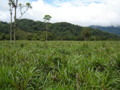
Without Trees
|

